Trail Ridge Road: A Family Guide to America's Highest Paved Drive
Stop-by-stop breakdown of the 48-mile route from Estes Park to Grand Lake, with elevation details, altitude strategy, wildlife tips, and 2026 timed entry rules.
Quick Answer
- Trail Ridge Road in Rocky Mountain National Park is the highest continuous paved road in North America, climbing to 12,183 feet across 48 miles between Estes Park and Grand Lake in 2026.
- 🚗 Drive time: 2 hours minimum without stops, 3-4 hours with viewpoints, short hikes, and the Alpine Visitor Center.
- ⚠️ Altitude warning: 20-30% of visitors experience altitude sickness. Don't drive Trail Ridge on your first day at elevation. Wait until Day 2 or later.
- 🏔️ Best stops for kids: Rock Cut for marmot and pika spotting, Alpine Visitor Center for exhibits and food, Holzwarth Historic Site for an easy walk to a 1920s dude ranch.
- 🎫 2026 timed entry: Required May 22 - Oct 12, 9 AM-2 PM ($2 reservation via Recreation.gov). Start early to skip the reservation window.
- 🥾 For hiking trails and more trip planning, check the Rocky Mountain Family Guide.
- 🧮 Build your full Rocky Mountain itinerary with our Visual Itinerary Builder to time your Trail Ridge drive perfectly.
Why Trail Ridge Road Deserves a Full Half-Day
There's a reason Trail Ridge Road shows up on nearly every "best drives in America" list. In under 50 miles, you'll climb from forested valleys at 8,000 feet to bare alpine tundra above 12,000 feet. Trees shrink, then vanish entirely. The air gets thin. And the views stretch for 100 miles on clear mornings.
But this drive can turn miserable fast if families aren't prepared. The summit can be 30 degrees colder than Estes Park. Afternoon thunderstorms roll in above tree line between June and August. And altitude sickness hits roughly one in four visitors who aren't acclimated. Every one of those problems is avoidable with planning.
2026 Timed Entry and Entrance Fees
Rocky Mountain National Park uses a timed entry system during peak season. Without a reservation during the required hours, rangers will turn your car around at the entrance station.
2026 Reservation and Fee Details
- Timed entry period: Reservations required May 22 through October 12, 2026, between 9 AM and 2 PM
- Reservation cost: $2 per vehicle through Recreation.gov
- Park entrance fee: $30 per vehicle for a 1-day pass, $35 for a 7-day pass
- Payment: Cards only at entrance stations. No cash accepted.
- Early bird strategy: Enter before 9 AM and you don't need a timed entry reservation at all
Starting by 7:30 or 8 AM means cooler temperatures, emptier pullouts, better wildlife sightings, and no reservation hassle. It also gets families below tree line before afternoon storms. A lot of problems solved by one early alarm.
Altitude Strategy for Families
Estes Park sits at roughly 7,500 feet. Trail Ridge Road peaks at 12,183 feet. That's higher than many ski resorts, and the body notices. About 20-30% of visitors experience some altitude sickness. Kids under 5 are especially susceptible, and they can't always describe what's wrong.
Altitude Rules for Trail Ridge Road
- Day 1: Stay below 10,000 feet. Explore Estes Park, do a lower-elevation hike, let everyone acclimate.
- Day 2+: Drive Trail Ridge Road after at least one night at altitude.
- Hydration: Drink far more water than feels necessary. Altitude dehydrates you faster than you'd expect.
- Alcohol: Skip it the first day. Alcohol worsens altitude effects significantly.
- Watch the kids: Unusual fussiness, loss of appetite, or wanting to sleep at odd times can signal altitude trouble.
- Descent is the cure: If anyone feels truly unwell above tree line, the fix is simple. Drive down. Symptoms usually improve within 30 minutes of losing elevation.
Don't fly into Denver and drive straight to 12,000 feet the same afternoon. One night in Estes Park is all it takes for most families to acclimate enough.
Estes Park hotels on Expedia — the in-town stays put you minutes from the east entrance for a 7:30 AM start, and most have free parking for the family vehicle.
Stop-by-Stop Guide: East to West
Drive east to west from Estes Park toward Grand Lake. Here's every worthwhile stop with elevations and highlights.
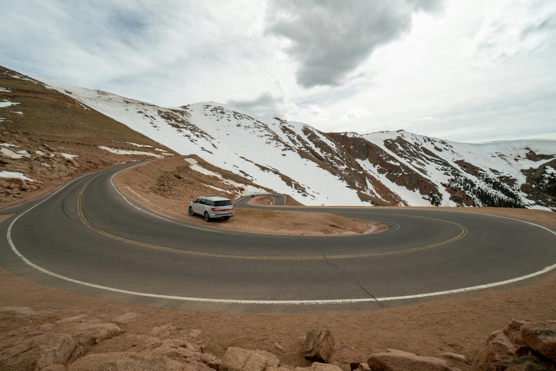
Stop 1: Many Parks Curve (9,640 ft)
The first big wow moment. This overlook reveals how Rocky Mountain got its name on the maps. Multiple valleys (the "parks") spread out below, framed by mountain ridges in every direction. It's a great photo stop and a nice warm-up before the road climbs above tree line. There's a paved parking area, but it fills fast after 10 AM.
Stop 2: Rainbow Curve (10,829 ft)
A sweeping panorama of Horseshoe Park below and the Mummy Range stretching north. Mt. Chapin (12,454 ft) dominates the skyline. You're near tree line here, so the transition from forest to tundra is visible in real time. Kids will notice the trees getting shorter and more twisted. Good spot to talk about how wind and cold shape the landscape.
Stop 3: Forest Canyon Overlook (11,716 ft)
A short paved walkway leads to a railing where you'll peer 2,500 feet straight down into Forest Canyon. It's dramatic. The Big Thompson River looks like a silver thread far below, and the canyon walls drop away sharply. Younger kids should hold hands here, not because the walkway is dangerous (it's well-fenced), but because the wind above tree line can be surprisingly strong.
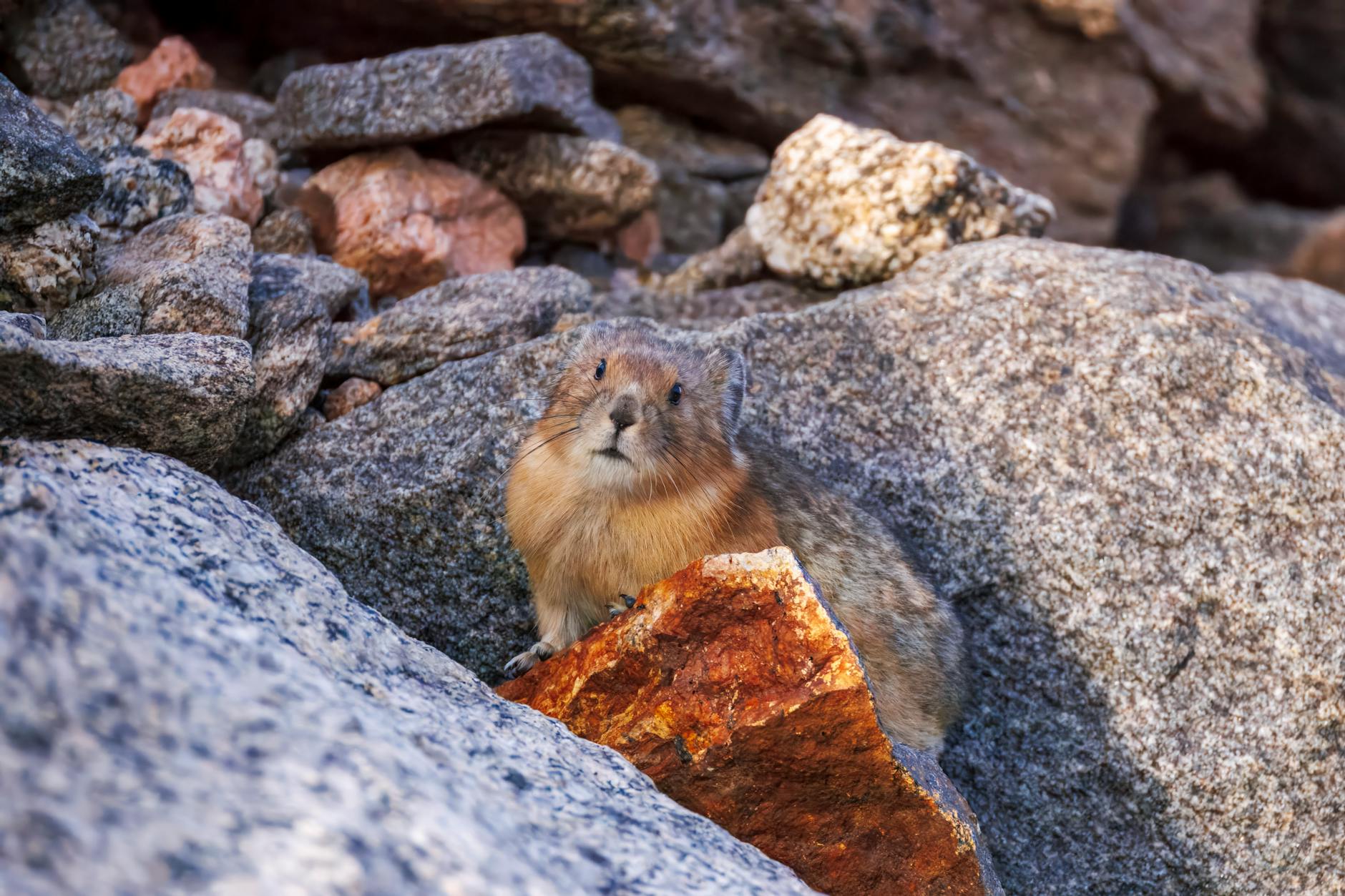
Stop 4: Rock Cut (12,110 ft)
The family favorite. The Toll Memorial Trail is a 1.1-mile round-trip paved path with about 150 feet of gain. It winds through boulder fields where yellow-bellied marmots sun themselves and pikas dart between crevices, squeaking at passersby. Kids love the hunt. Views extend to the Never Summer Mountains and Longs Peak on clear days.
Bighorn sheep sometimes appear here too. The trail offers fun rock scrambling for school-aged kids. Walk slower than normal at this altitude and take breaks often.
Stop 5: Alpine Visitor Center (11,796 ft)
The only real amenities on Trail Ridge Road. Gift shop, tundra ecology exhibits, a small cafe, and restrooms. This is the one food stop on the entire route.
The Tundra Communities Trailhead starts nearby, connecting to the same Toll Memorial Trail from the opposite direction. Junior Ranger booklets are available here, giving kids structured activities for the drive. The parking lot overflows by mid-morning on summer weekends.
Stop 6: Milner Pass and the Continental Divide (10,759 ft)
You've crossed the Continental Divide. Rain on the east side flows to the Atlantic; rain on the west heads to the Pacific. There's a sign marking the spot, great for a family photo. Kids learning geography love standing on the line where water's fate gets decided.
Poudre Lake sits next to the parking area. It's a calm spot if the family needs a breather.
Stop 7: Farview Curve Overlook
Now you're on the west side, looking down into the Kawuneeche Valley. This broad glacial valley is prime elk habitat. Morning and evening drives through this stretch often turn up herds grazing in the meadows below. Bring binoculars. Even from the overlook, you can sometimes spot elk as tiny brown dots moving through the valley floor.
Stop 8: Holzwarth Historic Site
A flat, roughly one-mile trail leads to the preserved buildings of a 1920s dude ranch. It's a piece of Colorado history that feels different from everything else on the drive. Kids can peek inside the old cabins and imagine what vacationing looked like a century ago.
Moose frequent the willows around the Colorado River near this trailhead. Keep your distance (they're big and unpredictable), but sighting one is a highlight of the drive for many families. Early morning is the best time to spot them.
Timing Your Drive and Beating the Weather
Afternoon thunderstorms above tree line between June and August are practically scheduled. Clouds build by noon, and lightning can strike exposed tundra by early afternoon. Being at 12,000 feet during a thunderstorm is dangerous.
Start by 8 AM, hit the summit by mid-morning, and descend by early afternoon. This also means better wildlife activity and less parking competition.
Timing Tips for Families
- Start from Estes Park by 7:30-8:00 AM
- Reach the alpine section (above tree line) by 9:00-9:30 AM
- Spend time at Rock Cut and Alpine Visitor Center mid-morning
- Cross Milner Pass and head down the west side by noon
- Be below tree line by 1:00-2:00 PM as storms build
- Temperature tip: it's 20-30 degrees colder at the summit than in Estes Park, even in July
If the weather looks bad in the morning, check the forecast before canceling. Alpine areas often clear first. But if there's a severe thunderstorm warning, postpone. There'll be other days.
What to Pack for Trail Ridge Road
The summit can be 40 degrees when Estes Park is 70. Wind chill makes it worse. Pack accordingly:
- Layers for everyone: A fleece or warm jacket per person, even in summer. Windbreaker over the top if you have one.
- Sun protection: SPF 50+ sunscreen, sunglasses, and hats. UV intensity increases significantly with altitude. You'll burn faster at 12,000 feet than at sea level.
- Water: At least 1 liter per person. Altitude causes dehydration faster than most people expect. More if you're planning to walk the Rock Cut trail.
- Snacks: The only food available is at the Alpine Visitor Center cafe, and the options are limited. Pack sandwiches, trail mix, fruit, and granola bars. Hungry kids at 12,000 feet are nobody's idea of fun.
- Sturdy shoes: Closed-toe shoes with grip for the short trails at Rock Cut and Forest Canyon Overlook. Sandals are a bad idea on rocky alpine terrain.
- Binoculars: For wildlife spotting at Kawuneeche Valley, Rock Cut, and Holzwarth. Worth the space in the daypack.
- Rain jackets: Even with an early start, weather can shift. Compact rain jackets take up almost no space and can save the day.
Wildlife Spotting Along the Route
The species change with elevation, which makes the drive feel like visiting different wildlife zones.
Marmots and pikas (Rock Cut and alpine areas): Yellow-bellied marmots sun themselves on boulders and are hard to miss. Pikas are smaller, quicker, and make a high-pitched "eek!" that kids find hilarious. Rock Cut is the single best spot for both.
Elk (Kawuneeche Valley and Farview Curve): Herds graze on the west side meadows, especially early morning and evening. During the fall rut (September-October), bull elk bugle across the valley. Always keep 25+ yards from elk.
Bighorn sheep (Rock Cut area): Less predictable, but they appear along rocky ridges. Scan slowly with binoculars since they blend into gray boulders.
Moose (Holzwarth Historic Site): Willows along the Colorado River are prime moose territory. Give them more space than elk. They're big and unpredictable.
Junior Ranger Program on Trail Ridge Road
Junior Ranger booklets (free at any visitor center) are really well-designed. Activities connect to what kids see along the drive: tundra plants, wildlife tracks, the Continental Divide. Pick one up before starting.
Kids complete activities at each stop and return the booklet to any visitor center for an official badge and swearing-in. It gives the drive structure for younger kids who might get bored between pullouts. Works best for ages 5-12, though younger kids can participate with help.
Round Trip or One-Way to Grand Lake
Most families drive east to west, turn around on the west side, and drive back. Half-day, simple, done.
The alternative is driving through to Grand Lake, a charming town with restaurants and a lakefront. The catch: getting back to Estes Park means either redriving Trail Ridge or looping on US-34 and I-70, adding about 2 extra hours.
Drive through to Grand Lake only if you're spending the night there or heading south toward other Colorado destinations. Otherwise, the round trip is the better call. You'll see different things in each direction as the light shifts.
Grand Lake lodging on Expedia — lakefront cabins and small lodges here let you split the drive over two days instead of looping back the same afternoon.
Practical Tips Families Should Know
- Restrooms: Alpine Visitor Center and a few pullouts. Don't wait until the summit.
- Car sickness: Winding road, especially the east side. Ginger candies help. Have plastic bags accessible.
- Strollers: Paved trails at Rock Cut and Forest Canyon work but aren't ideal. A carrier backpack is better for toddlers.
- Cell service: Spotty to nonexistent above tree line. Download offline maps before starting.
- Gas: Fill up in Estes Park. No gas stations until Grand Lake.
- Pets: Dogs aren't allowed on any trails in the park, including Rock Cut and Forest Canyon. Leave them at the hotel.
For more family hiking options near Trail Ridge Road, several trailheads along the route connect to longer hikes that school-aged kids can handle.
The Final Word on Trail Ridge Road
Trail Ridge Road isn't just a drive. It's the single best way to experience alpine tundra without a multi-hour hike. Where else can a five-year-old stand at 12,000 feet and watch marmots sunbathe while the Continental Divide stretches in both directions? Give it a full morning. Start early. Pack warm clothes and snacks. And don't drive it on your first day at altitude. (That one rule prevents most bad Trail Ridge experiences.) Kids remember this drive years later. Not because someone told them it was important, but because a pika screeched at them from a boulder while clouds rolled through the valley below. That's worth an early alarm. Planning a broader Rocky Mountain trip? The Rocky Mountain vs Glacier comparison helps families decide between two of the best mountain parks in the country.
Frequently Asked Questions
Trail Ridge Road typically opens in late May and closes by mid-October, depending on snowfall and weather. The 2026 timed entry period runs May 22 through October 12. The road can close temporarily at any time due to snow, ice, or severe weather, even during summer months. Check the Rocky Mountain National Park website for current road status before your drive.
Driving Trail Ridge Road takes a minimum of 2 hours without stops. Most families should plan 3-4 hours to enjoy viewpoints, short hikes, and the Alpine Visitor Center. Families who want to do the Rock Cut trail, explore Holzwarth Historic Site, and linger at viewpoints should budget a full half-day or more.
Trail Ridge Road is a fully paved, two-lane road that's safe for all standard vehicles. The main family concern is altitude sickness, not road conditions. About 20-30% of visitors experience some altitude symptoms above 10,000 feet. Drive Trail Ridge on your second day or later, keep everyone hydrated, and be prepared to descend if a family member feels unwell.
Yes, during peak hours. Rocky Mountain National Park requires timed entry reservations from May 22 through October 12, 2026, between 9 AM and 2 PM. Reservations cost $2 per vehicle through Recreation.gov. Entering before 9 AM avoids the reservation requirement entirely, making early morning starts the best strategy for families.
Pack warm layers even in summer, as temperatures at 12,000 feet run 20-30 degrees cooler than Estes Park. Essentials include a fleece or jacket per person, sunscreen SPF 50+, sunglasses, at least 1 liter of water per person, snacks (limited food available at Alpine Visitor Center only), and sturdy closed-toe shoes for short walks at overlooks.
Most families staying in Estes Park should drive east to west and return the same way as a round trip. Driving one-way through to Grand Lake adds variety but requires either redriving the road or looping back on US-34 and I-70, adding about 2 extra hours. The one-way option works best if you're spending the night in Grand Lake.
Trail Ridge Road offers excellent wildlife viewing year-round during its open season. Marmots and pikas are common at Rock Cut and alpine areas above tree line. Elk herds graze in Kawuneeche Valley, especially during morning and evening. Bighorn sheep occasionally appear near Rock Cut. Moose frequent the Holzwarth Historic Site area. Always keep at least 25 yards from all wildlife.